Leaflet Map

Leaflet Map icon
Leaflet Map is the ultimate WordPress plugin for easily creating beautiful interactive maps. Instantly add stylish vector maps to your WordPress website and customize them with attractive markers, popups, and more.
What We Think:
98%
Very highly recommended!

Leaflet Map: A Comprehensive Review

The Leaflet Map WordPress plugin is an open-source software created to help users create and manage customized maps through a WordPress interface. This plugin is an excellent tool for websites that showcase geographic locations or need to provide a route or direction on a website. It's also a great way for developers to manage interactive maps, from the convenience of a WordPress page.

Leaflet Map: Breakdown
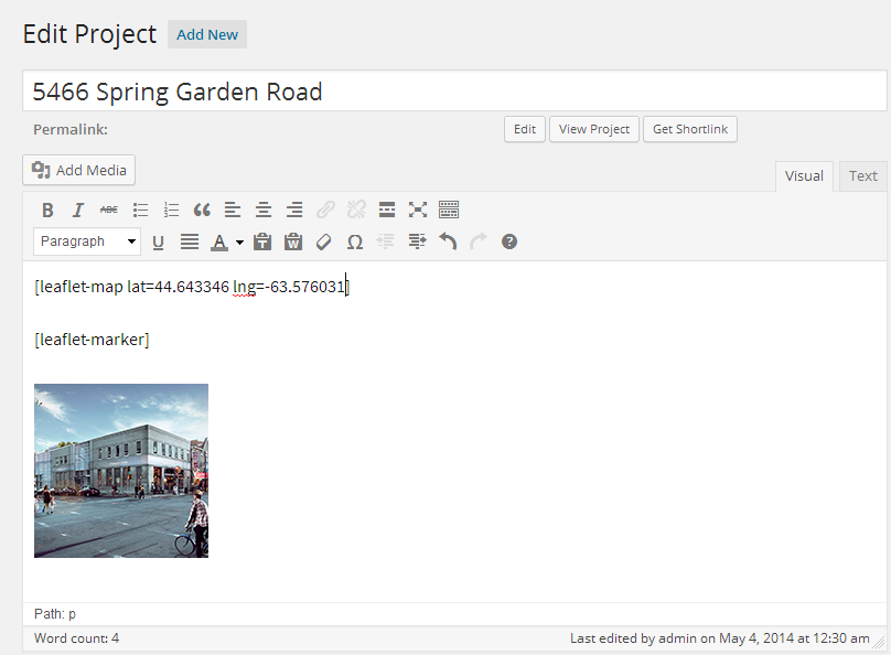
Put the shortcode into the post.

The Leaflet Map WordPress plugin is designed to be used for any website that wants to incorporate interactive maps. It is compatible with all web browsers and comes with several features to enhance user experience. With Leaflet Map, you can quickly and easily create your own interactive maps from within the WordPress dashboard. With a drag and drop menu, users can place markers, draw lines and shapes, and customize the view according to their own needs. While Leaflet Map is marketed as “easy to use”, it also provides a wealth of sophisticated tools that can power extensive customizations.

Leaflet Map comes with several customization settings that can make the map look the way you want it to look. The plugin provides an extensive set of colors, icons, and images that you can use to decorate the map. You can also add custom HTML labels at certain points for mileposts, milestones, and other points of interest. Even better, the plugin allows for layers to be added, such as geographic boundaries, custom data, and shapes. This way, users can add extra context to the map, to help tell a story or provide helpful information.

Leaflet Map also provides robust support for the WordPress Customizer. This allows users to make several adjustments to the map on the frontend, including changing the map type, map zoom level, and tile type. As a result, the map can be fine-tuned to look just how you want it and be more responsive to user input.

Pros of Using Leaflet Map

User-friendly Interface: Leaflet Map is one of the friendliest and most intuitive WordPress plugins for making interactive maps. The interface makes it easy to understand and use, enabling even beginners to manage and customise their maps with just a few clicks.

Excellent Features: Leaflet Map comes with a wide range of features that will make your maps look more professional and easier to use. You can set the map's center, zoom level, and map size, add layers for points of interest, and more. You also have the ability to quickly switch between map providers to ensure your maps look the best they can.

Open Source Technology: Leaflet Map is built on top of an open-source technology called Leaflet.js. This technology gives you access to all kinds of features and allows you to create custom maps. It also means the plugin is maintained and regularly updated for optimal performance.

Easy Embedding: With Leaflet Map, you can easily share your custom maps on a wide range of online or offline applications. This plugin allows you to embed a map into any web page, blog post, or social media post with just a few clicks.

Compatibility: Leaflet Map is compatible with all major browsers and devices so your maps can be viewed across all devices and platforms. This ensures that users can see your map regardless of the device they’re using.

Cons of Using Leaflet Map

Design Flexibility: Leaflet Maps has limited design customization options. It won’t allow customizing visual elements of the map such as customizing marker icons, adjusting the map size and shape, making the map controls visible, adding a background layer, and more. User can only choose from a handful of preset options.

Data Presentation: Leaflet Map is not suitable for advanced data presentation. This plugin is primarily focused on displaying static maps, so it does not offer the ability to visualize or interpret complex geospatial data like heatmaps, clustering, and other types of dynamic layers.

Developer Support: The plugin library provides limited support for developer’s questions. Users can’t obtain any technical support if they are facing any problems. As a result, developers have to figure out solutions on their own or look for other options.

Limited Layers: Leaflet Maps offer limited layers that a user can add in the map – letting users only be able to display basic map features such as roads and labels. This plugin doesn’t have an ability to add borders, tourism information, UTM grids, etc.

Security Issues: Leaflet Maps plugin is not tested for security vulnerabilities. Since it is a third-party plugin, it may not have strong security features to protect user data and therefore be more prone to potential cybercrimes like data theft, malware, and hacking. As a result, users should be extra vigilant while using it.

98% Very highly recommended!

In conclusion

For anyone who wants to add an interactive map to their WordPress website, the Leaflet Map plugin is an excellent choice. With support for a range of customization settings, responsive implementation, and a wealth of features, it can provide interactive maps that look great and are easy to manage. Plus, as an open-source solution, Leaflet Map is easy to customize if you have the coding knowledge. With Leaflet Map, you can have an interactive map on your website in no time.

Plugin Specifications
  • Version: 3.3.1
  • Last Updated: 1 year ago
  • Installs: 30,000+
  • WP Version: 4.6+
  • Tested Until: 6.3.2
  • PHP Version: N/A
Use Case Examples
  • Creating engaging hiking maps
    Close
    The Leaflet Map plugin makes it easy to create interactive maps for outdoor activities, such as hiking. With the help of the plugin, one can embed a map on the website and add points, labels, and animations to give the user an engaging and informative experience. The plugin also provides a variety of templates to choose from, allowing users to customize their maps to their heart’s content.
  • Tracking disaster relief efforts
    Expand
  • Finding public transit routes
    Expand
  • Delivering a virtual tour experience
    Expand
  • Presenting scientific data
    Expand
Tags
  • javascript
  • leaflet
  • map
  • mobile
  • openstreetmap